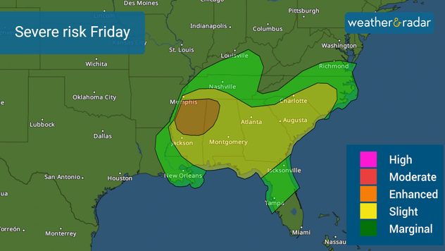
Página de inicio
Tiempo Los Angeles
Radar del Tiempo
Radar de lluvia
Radar de temperatura
Radar de viento
Radar de rayos
Noticias
Recomendado
Descubre la aplicación
Widget del tiempo
Contacto
Apps
Página de inicio / Artículos recomendados /

Another gigantic storm: Severe weather followed by polar temps

03:24 PM
12 de enero de 2024

Another gigantic storm
Severe weather followed by polar temps

The second gigantic winter storm of the week continues its course to the east of the country, bringing large and intense impacts of all kinds for Friday and Saturday.

After an early morning with some severe storms, mostly over Arkansas on Friday, that produced more than a dozen damaging winds reports and an equal number of hail reports, the low-pressure system will continue to increase the risk of storms this morning over the Southeast. A severe storm watch is in place for the northern half of Mississippi and this may expand to the northern half of Alabama once this system continues to move east.

Severe weather risk for Friday, mainly Friday morning for Mississippi & Alabama. Severe weather risk for Friday, mainly Friday morning for Mississippi & Alabama.

The arrival time of the storms over the Southeast is expected to be in the afternoon, which has limited the amount of warmth that this region will achieve, and this has decreased the risk of severity for Georgia, the Carolinas, and northern Florida, now at a level 2 out of 5 on the scale. Some severe storms may develop tornadoes, but the greatest risk will be from strong winds over 75 mph. Please be vigilant and limit your time outdoors if you are located in the area highlighted in yellow.

The cold front associated with this system loses strength as it moves over Florida, so the risk to Central Florida decreases even further, to a level 1 of 5. Central Florida could see isolated strong to severe storms by Friday night, with the biggest threat still being the winds.

A little of the same—a lot of rain for the Northeast

For the northeast of the country, Tuesday’s weather pattern repeats. Some snowfall will be affecting portions of the interior of the Northeast. Rain will be affecting much of the central Atlantic and the tri-state area during Friday afternoon and evening.

With this storm, I am also concerned about the strong storms that will be passing through the tri-state area during the early morning hours and Saturday morning. Some of these storms will bring heavy rains and could also bring severe weather such as tornadoes, destructive winds, and hail, especially over parts of New England. Residents of southern New England, including Boston, should be very attentive to what is happening with the storms. See the WeatherRadar focused on this region.

Strong winds

The strong winds will give more to talk about to end this week as well. Gusts that may exceed 75 mph will be likely across the Great Lakes region. Sustained wind will also be blowing strongly along the east coast of the United States. Also, the Tennessee Valley and Mississippi, all the way to Florida will still have strong winds on Saturday but with the direction changing the component will be mostly from the north, which will pull an extremely cold air mass across the region.

Frozen Plains!

A polar air mass moves over the Rockies and Plains. The cold will be intense and very dangerous. In the Plains the wind is added, making the situation even worse. Temperatures up to 40 degrees below normal for Sunday morning for portions of the Northern Plains and 15 degrees below normal for North Texas. In Dallas, residents will wake to temperatures around 16 degrees on Sunday.

We will continue to provide you with information about the evolution of this storm here in our app and through social networks.

**This same information can be seen in Spanish, written by our bilingual meteorologists if you set our app to Spanish inside the settings option on the top right. Tell your family and friends who only speak Spanish so that they can also be informed and stay safe, please.**

Irene Sans
Noticias destacadas
Mantén el suelo ligeramente húmedo antes de una helada, pero evita encharcamientos.
lunes, 12 de enero de 2026

Algunos consejos

Prepara a tus plantas para las heladas
Nube lenticular suave, con forma de lente, que se cierne sobre un cielo azul, con una forma ovalada aplanada distintiva y bordes suaves en capas, que destaca entre las nubes más finas que la rodean.
domingo, 18 de enero de 2026

Nubes lenticulares

"Platillos volantes" sobre Gales
viernes, 16 de enero de 2026

Eclipse solar total

Menos de 7 meses para el gran eclipse
Más noticias
Te puede interesar
Tormentas peligrosas esta noche
jueves, 8 de enero de 2026

Tormentas severas

Grandes cambios en todo el sur
miércoles, 14 de enero de 2026

Mitad de semana

La tormenta de viento llega con la masa de aire invernal
jueves, 15 de enero de 2026

Frío ártico

La semana termina gélida para el Sur, Este
Todas las noticias
Weather & Radar
US
Clima & Radar Brasil
Hava durumu & Radar Türkiye
Időjárás és Radar Magyarország
Καιρός & Ραντάρ Ελλάδα
Météo & Radar Belgique (Français)
Météo & Radar France
Meteo & Radar Italia
Meteo & Radar România
Météo & Radar Suisse (Français)
Meteo & Radars Latvija
OrasOnline Lietuva
Počasí & Radar Czechia
Počasie & Radar Slovensko
Pogoda & Radar Polska
Погода & Радар Україна (українська)
Tempo & Radar Portugal
Tiempo & Radar Argentina
Tiempo & Radar España
Vejr & Radar Danmark
Vreme & Radar Slovenija
Vreme & Radar Srbija
Vrijeme & Radar Bosna
Vrijeme & Radar Crna Gora
Vrijeme & Radar Hrvatska
Време & Радар България
Времето & Радар Macedonia
Weather & Radar India (English)
Weather & Radar Ireland
Weather & Radar United Kingdom
Weather & Radar USA (English)
Weer & Radar België (Nederlands)
Weer & Radar Nederland

Tiempo y Radar también está disponible en

Google Play StoreApp Store

Compañía

Contacto Protección de datos Aviso legal Declaración de accesibilidad

Servicios

Subir imagen

Redes sociales

instagramyouTube