Página de inicio
Tiempo Los Angeles
Radar del Tiempo
Radar de lluvia
Radar de temperatura
Radar de viento
Radar de rayos
Noticias
Recomendado
Descubre la aplicación
Widget del tiempo
Contacto
Apps
    Página de inicio / Noticias /

    Check the WindRadar - Spring's big winds

07:00 p.m.
19 de abril de 2026

Check the WindRadar
Spring's big winds

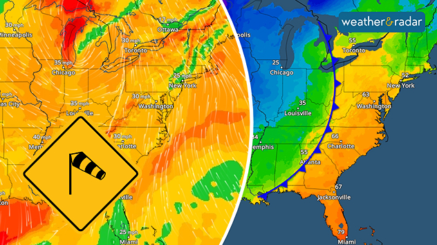
A strong cold front triggers gusty winds.
A strong cold front triggers gusty winds across the eastern U.S. as a storm system moves through.

As winter turns to spring, and as warm and cold air bring a roller coaster of temperatures, big wind gusts usually accompany the transition.

One day it's in the 70s with plentiful sunshine and evening thunderstorms. The next day, you're back in your winter coat with snow flurries and blustery winds. Many may even experience all four seasons in one day! This is all thanks to the clash of warm and cold air masses - creating big spring winds.

What is transition season?saber más

The winds are created by two atmospheric mechanisms over a small distance: a fast change in pressure or a fast change in temperature.

The TemperatureRadar can show you where a tight gradient of temperatures is occurring, thanks to a cold front. When this is happening, check the WindRadar. We bet you'll see gusty wind activity.

Learn more about the WindRadarsaber más
Becca Parker
Noticias destacadas
El otoño engulle Europa. Lluvias y más frío. . . domingo, 18 de octubre de 2026
domingo, 18 de octubre de 2026

Lluvias y más frío

El otoño engulle Europa
Tiempo tormentoso en el Mediterráneo. Aumenta el riesgo extremo. . . miércoles, 30 de septiembre de 2026
Imagen dividida. A la izquierda, un mapa meteorológico de España y Francia con precipitaciones, temperaturas y símbolos meteorológicos. A la derecha, una calle inundada con un coche.
miércoles, 30 de septiembre de 2026

Aumenta el riesgo extremo

Tiempo tormentoso en el Mediterráneo
Huracán Simón: México sigue preocupado. Fuerte huracán. . . lunes, 12 de octubre de 2026
El WindRadar muestra el huracán Simón frente a la costa del Pacífico de México, cerca de Puerto Vallarta. Los colores violeta y rojo indican los vientos más fuertes. A la izquierda se ve una cámara web de Jalisco.
lunes, 12 de octubre de 2026

Fuerte huracán

Huracán Simón: México sigue preocupado
Más noticias
Te puede interesar
Los frentes otoñales traen grandes cambios. Cómo localizarlos. . . viernes, 16 de octubre de 2026
viernes, 16 de octubre de 2026

Cómo localizarlos

Los frentes otoñales traen grandes cambios
La humedad procedente de Simón potencia la lluvia. Centro de EE. UU. . . miércoles, 14 de octubre de 2026
La humedad tropical procedente del huracán Simón, en el Pacífico, está potenciando enormemente las precipitaciones en algunas zonas de las llanuras centrales y meridionales. Debido a esta situación, se están registrando niveles de humedad sin precedentes.
miércoles, 14 de octubre de 2026

Centro de EE. UU

La humedad procedente de Simón potencia la lluvia
Un final de fin de semana lluvioso para algunos. Restos de Isaías. . . domingo, 11 de octubre de 2026
While Isaias may have made landfall near Destin, Fla., Friday night, the hurricane's remnants will bring a soggy end to the weekend hundreds of miles away from the point of landfall.
domingo, 11 de octubre de 2026

Restos de Isaías

Un final de fin de semana lluvioso para algunos
Todas las noticias
Weather & Radar

Tiempo y Radar también está disponible en

Google Play StoreApp Store

Compañía

Contacto Protección de datos Aviso legal Declaración de accesibilidad

Servicios

Subir imagen

Redes sociales

instagramyouTube