Página de inicio / Artículos recomendados /

Downpours, floods likely: This is your heads up Houston & surroundings

04:54 PM
18 de enero de 2024

Downpours, floods likely
Heads up Houston & surroundings!

Southeast Texas and western Louisiana residents must enjoy the weekend as the weather will quickly deteriorate early next week and bring heavy rounds of constant rain, which may increase the threat of flooding.

The weekend will start cold and breezy, borderline windy for the Texas coast and the western portion of the state. By Sunday, a trough will increase clouds along the coast. This trough is associated with a storm moving from the northeast portion of Mexico. On Monday there will be a warm front swinging over the Lone Star State, of course causing a temperature rollercoaster, but also keeping the clouds and scattered showers lingering around, as there will be the center of the low passing by the southern half of the state, pushing in a cold front on Tuesday.

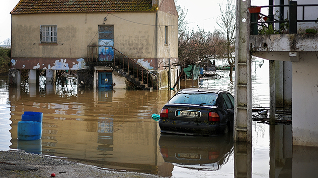
flooding car

But another storm comes for the one-two-punch on Wednesday with its cold front pushing through on Thursday morning.

This series of storms and front will keep the rains coming. Specifically, the heaviest storm period happening between Tuesday and Thursday, where parts of Southeast Texas will continue to top off their rain gauges accumulating another 2-3 inches in addition to the 1-3 inches received between Sunday and Tuesday. Of course, this rainfall forecast is only generally speaking, and there could be some areas where more persistent rainfall sets camp that could receive over 6 inches of rain.

We know prolonged rain activity over Southeast Texas brings special attention. There might be many with weather fatigue after this past week with winter weather. But we please ask you to stay weather aware and continue to monitor our app and our website. Our team of meteorologists will continue to keep you updated this week throughout the weekend and of course all next week.

This is a good time to have a secondary plan in case you have something set up for outdoors next week, especially between Monday and Thursday. Make sure you plan carefully and stay up to date with the forecast.

**This same information can be seen in Spanish, written by our bilingual meteorologists if you set our app to Spanish inside the settings option on the top right. Tell your family and friends who only speak Spanish so that they can also be informed and stay safe, please.**

Irene Sans
Noticias destacadas
sábado, 11 de octubre de 2025

El objetivo aún muy lejos

El tercer septiembre más cálido del mundo
El radar meteorológico muestra fuertes nevadas el jueves en las montañas escandinavas
jueves, 16 de octubre de 2025

Primera ola de frío

Fuertes nevadas en Escandinavia
La clave para verlos será buscar el cielo bien oscuro, alejado de la contaminación lumínica, con el horizonte despejado, ya que su posición en el cielo varía según el hemisferio.
domingo, 12 de octubre de 2025

Visitantes poco comunes

¡Se pueden ver dos cometas a la vez!
Más noticias
Te puede interesar
viernes, 10 de octubre de 2025

¿Qué significa?

Llega el fenómeno de La Niña, oficialmente
jueves, 2 de octubre de 2025

¿Desarrollo tropical?

Costa este de Florida con riesgo de inundaciones
miércoles, 1 de octubre de 2025

Bermudas en alerta

Imelda y restos de Humberto interactuan
Todas las noticias
Weather & Radar

es.weatherandradar.com

instagramyouTubeContacto
Protección de datos | Aviso legal | Declaración de accesibilidad