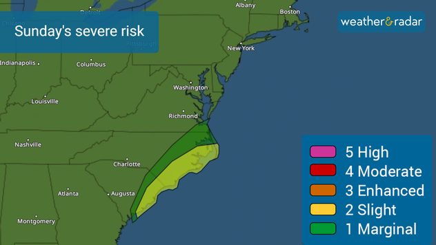
Página de inicio
Tiempo Los Angeles
Radar del Tiempo
Radar de lluvia
Radar de temperatura
Radar de viento
Radar de rayos
Noticias
Recomendado
Descubre la aplicación
Widget del tiempo
Contacto
Apps
    Página de inicio / Artículos recomendados /

    East Coast on alert: Coastal storms' flooding, major problems

06:31 p.m.
17 de diciembre de 2023

East Coast on alert
Coastal storm's flooding, major problems

Recommended external content from YouTube

We need your consent to show content from YouTube. You can withdraw your consent at any time.

I agree that content from YouTube will be displayed to me.

Settings for external content

Privacy policy

While Florida cleans up after the storm crossed the state leaving limbs down, and street flooding, parts of South Carolina have woken up to strong winds and minor surge flooding roads.

Major coastal flooding in South Carolina

The center of the storm borders Georgia and South Carolina, but the strong winds have impacted, straight onshore the northern coast of South Carolina and the southern coast of North Carolina, causing seawater to move onto low-lying streets. Downtown Charleston reported flooding Sunday morning and it worsened with the high tide coinciding with the strong onshore flow. Our Wind Radar shows winds at 50mph in Myrtle Beach around noon Sunday and stronger gusts are forecast in the afternoon.

Many other coastal towns will experience record or near-record flooding on Sunday afternoon. High rainfall rates could leave around 8 inches of rain. Not only heavier rainbands will continue to move in, but the high time times coincide with the strongest winds. A bad combination for coastal areas.

Strong to severe storms are also possible to move onshore in the coming hours as rainbands have embedded storms that could have some rotation. There is a risk for an isolated tornado to form. Please make sure to stay weather-aware if you are on the coast of the Carolinas through the afternoon.

Sunday's severe storm threat: flooding, damaging winds and tornadoes.

It is impossible to know if and where a tornado will develop. What we know is that conditions are favorable for tornadoes. Please make sure to have at least 3 ways of receiving weather alerts tonight.

What does a tornado warning mean?

A tornado warning means that a tornado has been detected, by radar or visually, and you should go to a safe location at your home or work.

The storm will pick up speed!

Weather will rapidly deteriorate over much of the Northeast on Sunday. Heavier downpours overnight through Monday morning are forecast across New York City through Boston. We do not forecast severe storms to move through the Northeast, but some spots could be dealing with flooding, especially those areas with poor drainage.

We are monitoring the weather overnight and will continue to bring you updates. If you can safely take pictures of flooding or damage that your area might have, please share them with us using our uploader or via social media, tag us!

**This information, written by our meteorologists, is also available in Spanish using our app in this language or in tiempoyradar.com

Irene Sans
Noticias destacadas
Fuertes tormentas en el norte de Italia. Granizo y tornados. . . sábado, 6 de junio de 2026
Imagen dividida en dos: por un lado, árboles caídos en una carretera; por otro, el radar meteorológico sobre el norte de Italia. Hay numerosas células tormentosas activas entre Turín, Milán y Bolonia.
sábado, 6 de junio de 2026

Granizo y tornados

Fuertes tormentas en el norte de Italia
Europa bajo un fuerte episodio de calor. ¿Nuevos récords?. . . lunes, 25 de mayo de 2026
lunes, 25 de mayo de 2026

¿Nuevos récords?

Europa bajo un fuerte episodio de calor
Calor inusual en el círculo polar ártico. Más de 20 grados. . . domingo, 17 de mayo de 2026
En el extremo norte de Europa, el tiempo se vuelve loco. Sobre el círculo polar ártico se mueve una masa de aire inusualmente cálido.
domingo, 17 de mayo de 2026

Más de 20 grados

Calor inusual en el círculo polar ártico
Más noticias
Te puede interesar
Florida pone las cosas al rojo vivo. sensación térmica en 100F. . . martes, 2 de junio de 2026
martes, 2 de junio de 2026

sensación térmica en 100F

Florida pone las cosas al rojo vivo
Observa un sistema convectivo de mesoescala. Radar del Tiempo. . . martes, 2 de junio de 2026
martes, 2 de junio de 2026

Radar del Tiempo

Observa un sistema convectivo de mesoescala
Aumenta la cobertura e intensidad de lluvias. Para Florida. . . miércoles, 27 de mayo de 2026
miércoles, 27 de mayo de 2026

Para Florida

Aumenta la cobertura e intensidad de lluvias
Todas las noticias
Weather & Radar

Tiempo y Radar también está disponible en

Google Play StoreApp Store

Compañía

Contacto Protección de datos Aviso legal Declaración de accesibilidad

Servicios

Subir imagen

Redes sociales

instagramyouTube