Página de inicio
Tiempo Los Angeles
Radar del Tiempo
Radar de lluvia
Radar de temperatura
Radar de viento
Radar de rayos
Noticias
Recomendado
Descubre la aplicación
Widget del tiempo
Contacto
Apps
    Página de inicio / Noticias /

    Heavy snow accumulates: Blizzard strike Northeast

04:03 p.m.
23 de febrero de 2026

Heavy snow accumulates
Blizzard strikes Northeast

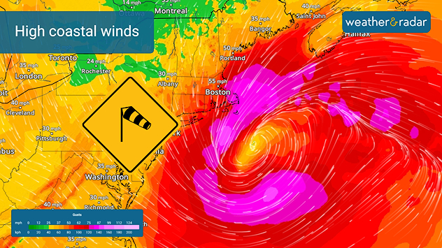
The one-two combination of heavy wet snow and winds gusting in excess of 35 mph is producing blizzard conditions along the coastal Northeast.

The WeatherRadar showed snow started on Sunday afternoon. It will continue through this afternoon along the I-95 corridor from Philadelphia to Boston. More than a foot of snow has already fallen in many places with more than 2 feet reported across parts of southern New England and in the greater New York City area and Long Island.

Coastal areas of New England could see wind gusts in excess of 55 mph through today.

The nor'easter producing the heavy snow is also producing extreme winds too. The WindRadar is showing wind gusts ranging from 35 mph to 65 mph, lasting well into this afternoon. Even higher gusts are occurring along the immediate New England coasts, causing blowing snow and white-out conditions. Blizzard warnings remain in effect through this afternoon.

The high winds have knocked out power to more than a quarter-million customers in Massachusetts, with more than 125,000 customers without power in New Jersey. Additional power outages are possible today.

James West

Noticias destacadas

Europa: días turbulentos. Viento y lluvia. . . martes, 17 de noviembre de 2026
martes, 17 de noviembre de 2026

Viento y lluvia

Europa: días turbulentos
¿Cómo actuar en caso de inundación?. Consejos. . . viernes, 20 de noviembre de 2026
Las inundaciones pueden ser peligrosas si nos sorprenden.
viernes, 20 de noviembre de 2026

Consejos

¿Cómo actuar en caso de inundación?
Riesgo de tormentas en el Adriático. Lluvia, tormenta y nieve. . . viernes, 13 de noviembre de 2026
El mapa de alertas muestra que, desde el jueves hasta el viernes, se producirán fuertes lluvias desde el norte de Italia, pasando por Eslovenia y Croacia, hasta Montenegro. Se prevén precipitaciones especialmente intensas en la costa norte del Adriático.
viernes, 13 de noviembre de 2026

Lluvia, tormenta y nieve

Riesgo de tormentas en el Adriático
Más noticias

Te puede interesar

Riesgo de tormentas severas el fin de semana. Puedes estar listo. . . viernes, 23 de octubre de 2026
viernes, 23 de octubre de 2026

Puedes estar listo

Riesgo de tormentas severas el fin de semana
El punto álgido de la lluvia de meteoritos de las Oriónidas. Ver estrellas. . . martes, 20 de octubre de 2026
martes, 20 de octubre de 2026

Ver estrellas

El punto álgido de la lluvia de meteoritos de las Oriónidas
La actividad por debajo de la media continúa. Sistema tropical se cocina. . . martes, 20 de octubre de 2026
martes, 20 de octubre de 2026

Sistema tropical se cocina

La actividad por debajo de la media continúa
Todas las noticias
Weather & Radar

Weather & Radar también está disponible en

Google Play StoreApp Store

Compañía

Contacto Protección de datos Aviso legal Declaración de accesibilidad

Servicios

Subir imagen

Redes sociales

instagramyouTube