Página de inicio
Tiempo Los Angeles
Radar del Tiempo
Radar de lluvia
Radar de temperatura
Radar de viento
Radar de rayos
Noticias
Recomendado
Descubre la aplicación
Widget del tiempo
Contacto
Apps
    Página de inicio / Artículos recomendados /

    Idalia to become a hurricane, threats

05:07 p.m.
27 de agosto de 2023

Eyes on Florida
Idalia to become a hurricane, threats

Tropical Depression 10 becomes Tropical Storm Idalia on Sunday. Hurricane Hunters are flying this system on Sunday morning, and the data collected will be crucial for model forecasts coming tonight and tomorrow morning as the system becomes better organized and finally gets moving. Intensify forecasts are also trending up, there are signs that Idalia could rapidly intensify as it travels over the water Gulf of Mexico. Florida will get all kinds of impacts from this system. Let’s discuss.

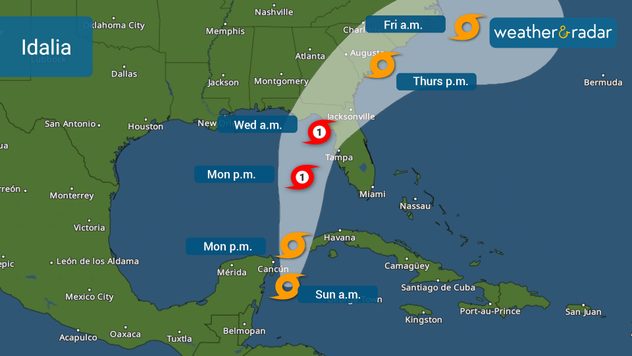
On Saturday afternoon, the National Hurricane Center officially labeled invest 93L, the system that brewing over the western Caribbean as Tropical Depression 10. This system will continue to be stationary over the same general area in the western Caribbean on Sunday. By Monday morning, we forecast the system to start moving and enter the Gulf of Mexico.

Once it’s over the warm waters of the Gulf of Mexico conditions become more favorable for the storm to become better organized and gain some strength. Idalis will likely become a hurricane on Tuesday, the third hurricane of this season. Its forward speed will also start to increase as this system gains strength.

The most favorable track.

Idalia's cone issued by the National Hurricane Center on Sunday early afternoon.

Sunday morning analyses showed that the center of the broad and messy system has reformed south of the initial center. This reorganization could shift the track a bit west. This means that on days 3 and 4 the system’s location will also be shifted a bit west. This morning the National Hurricane Center has not made drastic changes to the cone but be aware that any small changes could bring impact changes down the road, especially on days 3 to 5.

The National Hurricane Center does not have South Florida, east-central Florida, or southwest Florida in the cone of uncertainty. Idalia will likely hit somewhere along the Florida panhandle or the Big Bend area very early Wednesday morning. The Tampa Bay area should continue to monitor this storm closely. If it comes to making landfall over the Big Bend Region, the bay could see a larger storm surge starting on Tuesday and Wednesday. This is one of the main scenarios I pointed out in Friday’s forecast. Read it here.

Intensify forecasts

Intensity is always a tricky subject. But as mentioned on Friday, there are plenty of signs that are favorable for this system to gain some strength. There are plenty of warm waters over the eastern Gulf of Mexico, well above average for late August, and some models are starting to show rapid intensification. This means that Idalia could become a hurricane more intense than category one. For now, as much as a strong category 2 hurricane, almost 3.

Idalia’s main impacts to Florida and beyond

Since this track stays a little bit farther away from the west coast of Florida, especially from the southwest region, some rainbands will move over the southern Florida Keys as soon as Monday evening, then sweep north-northeast over South Florida and the Treasure Coast as the storm moves north, over the Gulf of Mexico. The center of the storm, as of Sunday morning is forecast to pass over 250 miles west of Fort Myers, but inch closer to the West coast as it travels north as it will be slightly turning to the northeast. Idalia will bring rain to the entire peninsula of Florida, but the highest rainfall amounts are forecast to fall over the area where landfall occurs and over the immediate west coast.

Hazards highly depend on your locationsaber más

The east coast of Florida is getting larger swells and danger of rip currents as Hurricane Franklin moves north over 600 miles east of Miami, but it is a large and strengthening system that is bringing marine impacts to the southeast Atlantic U.S. coast.

Idalia’s High Flash Flood Risk

Cities in west-central Florida, like Clearwater throughout Cedar Key the Big Bend area through Tallahassee, and Panama City Beach in the Panhandle could receive between 4 and 6 inches of rain, with some isolated spots with over 8 inches. Where the storm makes landfall, there could be more than 10 inches of rain, and most localized higher amounts. High rainfall volume is possible well inland as the system moves over Georgia and the Carolinas to end next week.

Winds will be strong and landfall location will be highly dependent on how much this hurricane strengthens on Tuesday, as it travels over the warm Gulf of Mexico waters. The strongest gust will hit the area to the right of the point of landfall. Power outages, flying debris, and down trees are all probable. The rainbands moving over Florida as the system moves over the Gulf, could also have embedded storms that could bring gusty winds and some of these storms could have some rotation, so the risk of a few isolated tornadoes on Tuesday and Wednesday is not ruled out.

Storm surge will be a big worry for areas along the Big Bend and possibly areas just north of Tampa. If the track shifts a little bit more east, this could be a bigger worry for the Tampa Bay area. As of the latest NHC advisory, the most dangerous storm surge is expected along Florida’s Big Bend. It is important to point out that a stronger system will also bring higher storm surge. Expect amounts to vary as the system intensifies.

After landfall, where does it go? Labor Day Weekend plans?

The current track calls for a landfall late Tuesday evening or in the wee hours of Wednesday.

But then Idalia will be gaining more forward speed and once over land, it will lose strength like crossing between the Florida-Georgia line. Depending on landfall location and final strength, it could still be a hurricane. Wednesday night and Thursday will be time to travel to Idalia over the Carolina coasts. Those residents and visitors will plan to start the Labor Day weekend a bit early should monitor the system as heavy rains and rough seas will be present across the Carolinas to finish off the week.

We will continue to monitor the system very closely and bring prompt updates on our app and weather and radar.com. Our team of meteorologists will be activated and will have a full task force on duty for much of the work week leading up to the busy and much-awaited Labor Day Weekend.

**This same information can be seen in Spanish, written by our bilingual meteorologists if your phone is set to Spanish and using our app too. Tell your family and friends who only speak Spanish so that they can also be informed and stay safe, please.**

Irene Sans
Noticias destacadas
España se prepara: llega el eclipse. Todos los detalles. . . martes, 11 de agosto de 2026
Llega uno de los días más esperados del año para los amantes de la astronomía, y también para los que no lo son. Este 12 de agosto tendrá lugar el eclipse total de Sol.  
martes, 11 de agosto de 2026

Todos los detalles

España se prepara: llega el eclipse
Los rayos caen en terreno seco. Mira el radar de rayos. . . martes, 18 de agosto de 2026
Las imágenes del golfo de Liguria, cerca de Génova, lo muestran de forma impresionante.
martes, 18 de agosto de 2026

Mira el radar de rayos

Los rayos caen en terreno seco
Tus momentos del eclipse solar en España. Videos y fotos. . . miércoles, 12 de agosto de 2026
Ha llegado el momento de recopilar algunos de los increíbles vídeos que nos habéis enviado del eclipse solar.
miércoles, 12 de agosto de 2026

Videos y fotos

Tus momentos del eclipse solar en España
Más noticias
Te puede interesar
El huracán Lala pasa al sur de Hawaí. Inundaciónes y viento. . . domingo, 16 de agosto de 2026
domingo, 16 de agosto de 2026

Inundaciónes y viento

El huracán Lala pasa al sur de Hawaí
20 días con una temperatura de por lo menos 100 °F. Llanuras del Sur. . . jueves, 20 de agosto de 2026
jueves, 20 de agosto de 2026

Llanuras del Sur

20 días con una temperatura de por lo menos 100 °F
Observa cómo interactúan los grupos de tormentas. Un Radar muy activo. . . martes, 11 de agosto de 2026
martes, 11 de agosto de 2026

Un Radar muy activo

Observa cómo interactúan los grupos de tormentas
Todas las noticias
Weather & Radar

Tiempo y Radar también está disponible en

Google Play StoreApp Store

Compañía

Contacto Protección de datos Aviso legal Declaración de accesibilidad

Servicios

Subir imagen

Redes sociales

instagramyouTube