Página de inicio / Noticias /

Milton is born, extensive impacts expected for Florida

08:04 PM
5 de octubre de 2024

A hurricane by Monday
Milton is born, extensive impacts expected for Florida

Tropical Storm Milton formed on Saturday morning. The official track shows a hurricane making landfall on the west coast of Florida on Wednesday.

The initial forecast called for a low chance of development, as the models were picking off a tropical wave moving over the Western Caribbean. However, as always mentioned, the models are often unreliable without well-defined low pressure. Milton formed from the remnants of a low-pressure system that came from the Pacific and crossed southern Mexico—this is something the models never picked up, as they were picking up the western Caribbean disturbance instead.

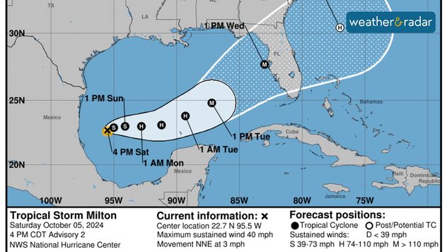
What's happening? What is likely to happen?

The National Hurricane Center notes a Category 3 hurricane (at least) making landfall between Southwest Florida and the Tampa Bay area on Wednesday morning. This would be the fifth land falling hurricane on the U.S. mainland this season. Areas from the Big Bend through the Southwest need to start preparing, and we understand that this comes when you are still healing from Helene. Please take this seriously. If Milton were to make landfall just north of Tampa Bay, the surge would be catastrophic, and there would be extensive power outages all across Central Florida.

Southwest Florida needs to prepare for a significant storm surge, considering that if the track shifts south, there could be more storm surge. For Southeast Florida, under the current track, the worst day will be Wednesday, with winds and rains picking up on Tuesday. There will likely be tropical storm-force winds with gusts above 74 mph (hurricane strength). If the track shifts south, then higher winds would be experienced. If the track shifts northward (north of Tampa), fewer hurricane gusts could be experienced. There is still the chance for power outages across the southern portion of the peninsula.

Milton will gradually strengthen, but it is ultimately heading toward Florida, and a west-to-east movement is a very bad scenario for the West Coast. Also, considering that the dirty side of the system, the one with the strongest winds and heaviest rains, will cover much of South Florida, over highly populated areas, and a Central Florida landfall would put millions at risk. The expected rain is between 6 to 10 inches across the Peninsula. Highly populated areas across Southeast Florida will deal with heavy rains and flash flood risk early next week.

Please take this weekend to make sure you have your supplies topped off. If you have one and have not tested your generator, do so this weekend. Get board games for the kids, and make sure to get portable power banks to keep them charged.

**Para información en español por favor visite tiempoyradar.com**

Irene Sans
Noticias destacadas
Algunos modelos meteorológicos estacionales nos permiten conocer cómo podría comportarse la estación.
martes, 2 de diciembre de 2025

¿Qué se espera?

Arranca el invierno meteorológico
Niebla afectando a los Montes Apalaches.
sábado, 29 de noviembre de 2025

Nubes bajas

10 datos sobre la niebla
Personas vadeando una calle inundada, junto a un mapa meteorológico con un ciclón sobre Sri Lanka. Representación de las consecuencias de la tormenta y los campos de viento actuales.
martes, 2 de diciembre de 2025

Muertos en Sri Lanka

El ciclón provoca graves inundaciones
Más noticias
Te puede interesar
domingo, 9 de noviembre de 2025

Termina la temporada

¿Son frecuentes los huracanes en noviembre?
viernes, 14 de noviembre de 2025

Inundación, evacuaciones

Potente tormenta en el Sur de California
miércoles, 12 de noviembre de 2025

Riesgo de inundaciones

Las fuertes lluvias amenazan la costa oeste
Todas las noticias
Weather & Radar

Tiempo y Radar también está disponible en

Google Play StoreApp Store

Compañía

Contacto Protección de datos Aviso legal Declaración de accesibilidad

Servicios

Subir imagen

Redes sociales

instagramyouTube