Página de inicio
Tiempo Los Angeles
Radar del Tiempo
Radar de lluvia
Radar de temperatura
Radar de viento
Radar de rayos
Noticias
Recomendado
Descubre la aplicación
Widget del tiempo
Contacto
Apps
    Página de inicio / Artículos recomendados /

    Multiday severe outbreak: Tornadoes, winds and significant flooding

03:39 PM
9 de enero de 2024

Multiday severe outbreak
Tornadoes, winds & significant flooding

The multiday severe weather risk continues Tuesday. Overnight there were 6 preliminary tornadoes reported across parts of southern Alabama and northern Georgia, with five preliminary wind reports. More tornadoes and strong winds are coming this afternoon into the evening for places more east, along with a significant flooding risk across the Northeast.

What’s happening?

The low-pressure system continues to intensify on Tuesday as it crosses the Southeast. This low-pressure system is lighting up weather maps with an incredible number of alerts of all kinds. Northern Florida and southern Georgia woke up to tornado watches in effect and storms moving through. This means conditions are possible for tornadoes to develop during the morning hours.

Strong winds are possible across a large chunk of the nation-- from Texas through the entire East Coast.

From Texas, across the Mississippi Valley through the Northeast, including the Southeast and all of Florida, there are wind alerts in effect. Wind gusts could be above 60 mph, especially along the Appalachians. North Florida through the coastal areas of the Carolinas could also have strong wind gusts between 40 to 60 mph.

As far as precipitation goes, this powerful low-pressure system brings all kinds. Heavy snowfall is still in the forecast for parts of the Midwest through the Great Lakes area. Our meteorologist James West has specifically written a forecast article for the winter precipitation.

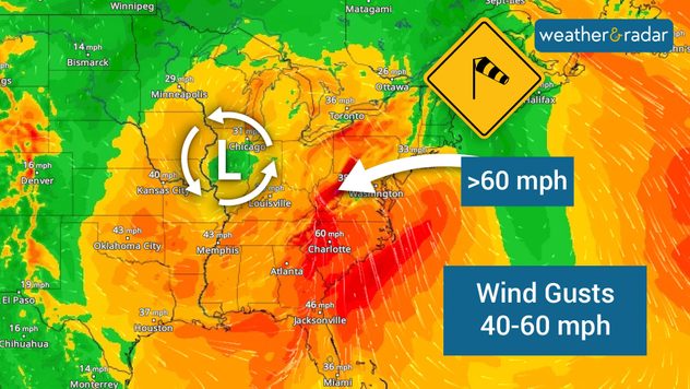
Severe weather risk – enhanced.

As far as the severe weather risk goes, the highest threat of the day, level 3 out of five, an enhanced, is located over northern Florida, southern Georgia, and the eastern half of the Carolinas. Large cities such as Jacksonville, Fla. Tallahassee, Fla., Savannah Ga., Gainesville Fla., and Fayetteville, N.C., are under enhanced risk. But even larger cities such as Charlotte, N.C., Raleigh N, C., Tampa, and Orlando, Fla., are under a slight risk, meaning level 2 out of five on the severity scale.

Impacts

The main risk for severe thunderstorms is from damaging wind gusts as the storms sweep through, but there's also a significant tornado risk, especially for the eastern half of the Carolinas later on this afternoon. Make sure to have at least three ways to receive weather alerts during the next 24 hours, especially if you live along the East Coast of the nation.

Timing

The severe weather is more likely across the enhanced area, especially over the Carolinas, after noon, while across northern Florida and southern Georgia late this morning too. Central Florida should stay weather-aware through the early evening hours. South Florida could also experience some isolated strong storms this evening.

The center of the storm will inch closer to the Northeast and the heaviest rains are forecast to arrive after 3 p.m. and continue through at least 3 a.m. That’s 12 hours of rain, which many will be on the heavy side!

Significant flooding for the northeast

After all the recent snow and rain that has fallen during the last few weeks, riverbanks continue to be rather full. There are still some places across upstate New York and the interior portions of New England with a large snowpack from this weekend’s storm.

This low-pressure system will bring heavy rain to these same areas. This means that whatever snowpack there is present will melt quickly. This quick melting will cause significant flooding across areas, especially near riverbanks.

As the melted snow and today’s heavy rains continue to run downstream there could be more significant flooding, especially across New Jersey. Locally heavy amounts of rain are possible across the tri-state area in the largest populated cities. Remember to turn around, don't drown!

We will continue to monitor the weather today, bringing you updates. Please follow the recommendations of local authorities. If you still have Christmas decorations outside, it's a good idea to pick them up, because the wind can cause them to fly away, and they could become projectiles.

**This same information can be seen in Spanish, written by our bilingual meteorologists if you set our app to Spanish inside the settings option on the top right. Tell your family and friends who only speak Spanish so that they can also be informed and stay safe, please.**

Irene Sans
Noticias destacadas
Con la llegada de un frente frío, el aire polar se adentra mucho hacia el sur.
martes, 12 de mayo de 2026

Lluvia, tormenta y nieve

Cambio brusco de tiempo en Europa
Las tormentas vespertinas están descargando con potencia en muchas zonas de España. El granizo ha sido el protagonista en varias localidades y zonas del país.  
sábado, 9 de mayo de 2026

Pueblos teniños de blanco

El granizo descarga con fuerza en España
miércoles, 6 de mayo de 2026

En España

Abril 2026: el más cálido de la historia
Más noticias
Te puede interesar
Crédito: Mark Maxwell - St. Joseph, Míchigan.
sábado, 16 de mayo de 2026

¿Y algunos fracasos?

¿Por qué algunas puestas de sol son tan bonitas?
lunes, 11 de mayo de 2026

De Milwaukee a Chicago

La brisa del lago refresca el ambiente
La ola de calor que afecta a la mitad occidental de Estados Unidos alcanza hoy su punto álgido, y se prevén más de una docena de récords de temperatura máxima.
martes, 12 de mayo de 2026

Máximas de hoy

Olas de calor sin precedentes en el oeste
Todas las noticias
Weather & Radar

Tiempo y Radar también está disponible en

Google Play StoreApp Store

Compañía

Contacto Protección de datos Aviso legal Declaración de accesibilidad

Servicios

Subir imagen

Redes sociales

instagramyouTube