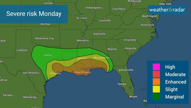
Página de inicio
Tiempo Los Angeles
Radar del Tiempo
Radar de lluvia
Radar de temperatura
Radar de viento
Radar de rayos
Noticias
Recomendado
Descubre la aplicación
Widget del tiempo
Contacto
Apps
Página de inicio / Artículos recomendados /

Over 20 million at risk: Multi-day severe storm outbreak possible

02:49 PM
8 de enero de 2024

Over 20 million at risk
Multi-day severe storm outbreak possible

This first week back to school for many brings the chance for severe storms across the South on Monday and then over the Southeast on Tuesday. For both days combined, there are 20 million at risk of experiencing severe conditions.

The next storm system sweeps from west to east, pushing a strong cold front, increasing the chance for one or two tornado outbreaks and the potential for hail and damaging wind gusts with the storms. There is plenty of warm air channeling in with the warm front pushing north. This will prime the atmosphere on Monday and will crash with the cold front passing through in the latter part of the day, sweeping everything eastward with a line of storms - many could be severe.

Severe weather for Monday night to Tuesday morning. Severe weather for Monday night to Tuesday morning.

Monday night into Tuesday storms

The enhanced risk, level 3 out of 5, threatens Houston, New Orleans, Mobile, Alabama through Pensacola, Florida.

The risk of severe storms starts Monday night and goes into Tuesday from Southeast Texas through the Florida Panhandle. It will likely be a line of storms barreling from the west over the southeastern portion of the Lone Star State to be first affected, then Louisiana and southern Arkansas, then Mississippi, and Alabama, ending in northwest Florida in this period.

Tuesday’s threat

The threat for Tuesday increases in size for Tuesday. Over 11 million people are at risk of experiencing severe conditions and are under an enhanced risk, level 3 out of 5, from Jacksonville to Tallahassee, extending across southern Georgia and the coast of the Carolinas. But don’t underestimate the slight risk, as large cities such as Tampa and Orlando, Florida also have a chance of getting some severe storms moving through the region after 2 p.m. ET, see our WeatherRadar.

Keep in mind that considering the system will likely grow stronger on Tuesday, there is the chance for the risk to also grow. Please stay weather aware and the “bullseye” of the most at-risk locations could be better defined later Monday or even Tuesday morning.

The main threats

These storms could produce widespread damaging winds and a few tornadoes. Hail is also a possibility. Heavy rain will be an issue on Monday for New Orleans and southern Mississippi.

Please make sure to have 3 ways of receiving weather alerts and revise your emergency plans, such as a safe place you would be in case a severe thunderstorm warning or tornado warning is issued for your location.

Our team of meteorologists is carefully monitoring the evolution of this system and will bring you frequent updates on our app and across all our social media platforms.

**This same information can be seen in Spanish, written by our bilingual meteorologists if you set our app to Spanish inside the settings option on the top right. Tell your family and friends who only speak Spanish so that they can also be informed and stay safe, please.**

Irene Sans
Noticias destacadas
El radar de temperatura muestra hasta 50 grados en el sureste de Australia.
lunes, 26 de enero de 2026

Casi 50 grados

Calor extremo en Australia
Ciudad densamente urbanizada al borde de un acantilado rocoso escarpado y erosionado. En primer plano, laderas verdes y profundos desprendimientos.
miércoles, 28 de enero de 2026

Tras las fuertes lluvias

Deslizamiento de tierra en Sicilia
La causa principal de la crisis climática es el dióxido de carbono, que llega a la atmósfera, entre otras cosas, a través de las centrales térmicas de carbón.
sábado, 17 de enero de 2026

Entre los primeros 3

2025 fue el tercer año más cálido
Más noticias
Te puede interesar
domingo, 25 de enero de 2026

Fin de semana caótico

Cortes de energía, nieve, hielo y tormentas severas
Se avecina una semana fría
miércoles, 21 de enero de 2026

Frío peligroso

Se acerca una ola de frío ártico
martes, 27 de enero de 2026

3er día sin electricidad

El sur se recupera lentamente del hielo
Todas las noticias
Weather & Radar
US
Clima & Radar Brasil
Hava durumu & Radar Türkiye
Időjárás és Radar Magyarország
Καιρός & Ραντάρ Ελλάδα
Météo & Radar Belgique (Français)
Météo & Radar France
Meteo & Radar Italia
Meteo & Radar România
Météo & Radar Suisse (Français)
Meteo & Radars Latvija
OrasOnline Lietuva
Počasí & Radar Czechia
Počasie & Radar Slovensko
Pogoda & Radar Polska
Погода & Радар Україна (українська)
Tempo & Radar Portugal
Tiempo & Radar Argentina
Tiempo & Radar España
Vejr & Radar Danmark
Vreme & Radar Slovenija
Vreme & Radar Srbija
Vrijeme & Radar Bosna
Vrijeme & Radar Crna Gora
Vrijeme & Radar Hrvatska
Време & Радар България
Времето & Радар Macedonia
Weather & Radar India (English)
Weather & Radar Ireland
Weather & Radar United Kingdom
Weather & Radar USA (English)
Weer & Radar België (Nederlands)
Weer & Radar Nederland

Tiempo y Radar también está disponible en

Google Play StoreApp Store

Compañía

Contacto Protección de datos Aviso legal Declaración de accesibilidad

Servicios

Subir imagen

Redes sociales

instagramyouTube