Página de inicio
Tiempo Los Angeles
Radar del Tiempo
Radar de lluvia
Radar de temperatura
Radar de viento
Radar de rayos
Noticias
Recomendado
Descubre la aplicación
Widget del tiempo
Contacto
Apps
    Página de inicio / Noticias /

    Storms for the Plains, Mid-South

02:05 p.m.
1 de junio de 2026

Damaging wind & hail
Storms for the Plains, Mid-South

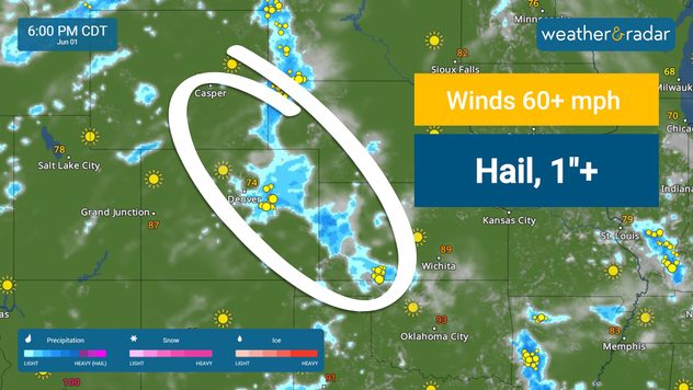
Strong storms target two regions of the U.S. today- the Plains and the Mid-South. Damaging winds and hail are the main threats.

The WeatherRadar shows thunderstorms capable of producing large hail and damaging wind gusts developing this afternoon and evening across portions of the central Plains. Severe weather may impact cities such as Denver, Cheyenne, Wyo., McCook, Neb., and Garden City, Kan.

Strong storms may produce wind gusts higher than 60 mph and hail one inch in diameter or greater.

Farther east and south, scattered to numerous strong-to-severe wind gusts may also occur from the Ozarks into parts of the Southeast. Abundant Gulf moisture will provide ample fuel for storm development before noon today. Storms will fire up through the early afternoon in cities like Nashville and Memphis, Tenn.

A second round of storms may develop across this region this afternoon and evening. Severe storms will also be possible in cities such as Little Rock, Ark., Jackson, Miss., and Birmingham, Ala., in addition to more action across portions of western and middle Tennessee.

Mary Mays
Noticias destacadas
Altas presiones y el calor extremo. Te explicamos. . . sábado, 22 de agosto de 2026
altas presiones y calor extremo
sábado, 22 de agosto de 2026

Te explicamos

Altas presiones y el calor extremo
¿Es fiable el termómetro del vehículo?. El más usado. . . domingo, 23 de agosto de 2026
El termómetro del coche puede no ser fiable en ocasiones.
domingo, 23 de agosto de 2026

El más usado

¿Es fiable el termómetro del vehículo?
Los rayos caen en terreno seco. Mira el radar de rayos. . . martes, 18 de agosto de 2026
Las imágenes del golfo de Liguria, cerca de Génova, lo muestran de forma impresionante.
martes, 18 de agosto de 2026

Mira el radar de rayos

Los rayos caen en terreno seco
Más noticias
Te puede interesar
Un tornado toca tierra en Port St. Lucie. Daños a estructuras. . . martes, 25 de agosto de 2026
El Radar del Tiempo muestra la tormenta que resultó en el tornado cerca de Port Saint Lucie, Florida.
martes, 25 de agosto de 2026

Daños a estructuras

Un tornado toca tierra en Port St. Lucie
El déficit de precipitaciones supera el pie. Sureste de Florida. . . martes, 18 de agosto de 2026
martes, 18 de agosto de 2026

Sureste de Florida

El déficit de precipitaciones supera el pie
Días con temperaturas nocturnas récord. Un toque tropical. . . lunes, 17 de agosto de 2026
lunes, 17 de agosto de 2026

Un toque tropical

Días con temperaturas nocturnas récord
Todas las noticias
Weather & Radar

Tiempo y Radar también está disponible en

Google Play StoreApp Store

Compañía

Contacto Protección de datos Aviso legal Declaración de accesibilidad

Servicios

Subir imagen

Redes sociales

instagramyouTube