Página de inicio
Tiempo Los Angeles
Radar del Tiempo
Radar de lluvia
Radar de temperatura
Radar de viento
Radar de rayos
Noticias
Recomendado
Descubre la aplicación
Widget del tiempo
Contacto
Apps
    Página de inicio / Noticias /

    Summer preview concludes - Big Weekend cooldown

07:19 p.m.
16 de abril de 2026

Summer preview concludes
Big Weekend cooldown

The East and South might be baking under an early summer-like heat wave, but colder weather will spread across the U.S. this weekend.

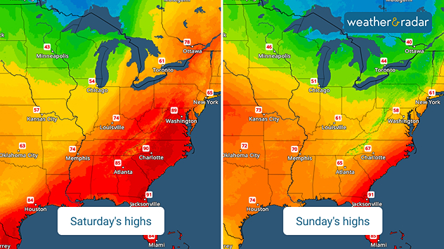
The TemperatureRadar is showing most places east of the Rockies in the 80s with a few 90s in the Mid-Atlantic today. These hot temperatures are interacting with a slow-moving storm system to produce more severe storms across the Northeast and part of the Midwest and the Ohio Valley.

This is just a small preview of the big changes ahead. A storm system moving out of western Canada will drag a potent cold front across the Plains late Friday and Saturday before moving into the East and South on Sunday.

The WeatherRadar shows this system producing heavy rain and thunderstorms along its path. In the wake, a significantly colder air mass will settle southward across the U.S. Afternoon highs on Saturday will only be in the 50s and 60s across the southern Plains, while Minneapolis will be in the 40s and Chicago will barely hit 50s.

Minneapolis

ju
44
50
vi
45
54
sá
36
62
do
46
67
lu
44
65
ma
44
68
mi
52
68
ju
52
67
vi
52
67
sá
48
57
do
45
55
lu
42
56
ma
44
59
mi
43
58
máx. (°F)
mín. (°F)
másmenos

By Sunday, the East and South will only be in the 50s and 60s. This is in stark contrast to the 80s and 90s expected today.

James West
Noticias destacadas
Tiempo tormentoso en el Mediterráneo. Aumenta el riesgo extremo. . . miércoles, 30 de septiembre de 2026
Imagen dividida. A la izquierda, un mapa meteorológico de España y Francia con precipitaciones, temperaturas y símbolos meteorológicos. A la derecha, una calle inundada con un coche.
miércoles, 30 de septiembre de 2026

Aumenta el riesgo extremo

Tiempo tormentoso en el Mediterráneo
Inundaciones mortales en España y Grecia. Tiempo severo. . . sábado, 10 de octubre de 2026
Las fuertes lluvias y las tormentas han causado grandes daños en España y Grecia, este pasado fin de semana. En España, las provincias más afectadas han sido Barcelona y Girona En 24 horas varias estaciones han superado los 200 litros por metro cuadrado entre el 3 y el 4 de octubre.
sábado, 10 de octubre de 2026

Tiempo severo

Inundaciones mortales en España y Grecia
Situación adversa en el Mediterráneo. Lluvia y tormenta. . . viernes, 2 de octubre de 2026
Sigue la evolución a tiempo real desde el radar del tiempo.
viernes, 2 de octubre de 2026

Lluvia y tormenta

Situación adversa en el Mediterráneo
Más noticias
Te puede interesar
Un final de fin de semana lluvioso para algunos. Restos de Isaías. . . domingo, 11 de octubre de 2026
While Isaias may have made landfall near Destin, Fla., Friday night, the hurricane's remnants will bring a soggy end to the weekend hundreds of miles away from the point of landfall.
domingo, 11 de octubre de 2026

Restos de Isaías

Un final de fin de semana lluvioso para algunos
La humedad procedente de Simón potencia la lluvia. Centro de EE. UU. . . miércoles, 14 de octubre de 2026
La humedad tropical procedente del huracán Simón, en el Pacífico, está potenciando enormemente las precipitaciones en algunas zonas de las llanuras centrales y meridionales. Debido a esta situación, se están registrando niveles de humedad sin precedentes.
miércoles, 14 de octubre de 2026

Centro de EE. UU

La humedad procedente de Simón potencia la lluvia
Se podría igualar un récord de 145 años. Ola de calor. . . miércoles, 14 de octubre de 2026
miércoles, 14 de octubre de 2026

Ola de calor

Se podría igualar un récord de 145 años
Todas las noticias
Weather & Radar

Tiempo y Radar también está disponible en

Google Play StoreApp Store

Compañía

Contacto Protección de datos Aviso legal Declaración de accesibilidad

Servicios

Subir imagen

Redes sociales

instagramyouTube