Página de inicio / Artículos recomendados /

Tropical update: Lee strengthens, why would it turn?

02:49 PM
7 de septiembre de 2023

Tropical update
Lee strengthens, why would it turn?

I am starting this article by stating that aside from Lee becoming a hurricane and continuing to strengthen today, which we already discussed yesterday, there are not many changes to our forecast. Lee is expected to go through rapid intensification during the next 24 hours and chances are growing for it to make a turn, also as we discussed on Wednesday.

Lee is the 4th hurricane of the season, and we are about 10 days ahead of the average date when the fourth hurricane forms.

On Thursday morning Lee is a category 1 hurricane, but by late Thursday or early Friday, Lee will be a category 3. This means that today is the day that Lee is free to gain as much strength as possible, going through rapid intensification.

Its center is likely to stay a safe distance away from the northeastern Caribbean islands. Nonetheless, it will bring very rough seas to the Lesser Antilles, especially for the northern portions, Puerto Rico, and the northern coast of Hispaniola in the coming days.

Hurricane Lee's track issued by the National Hurricane Center on Thursday morning. Hurricane Lee's track issued by the National Hurricane Center on Thursday 11am

This system is losing speed, so there will be many days passing by, and we will be talking about Lee for the rest of this week, weekend, and next week too.

We have received lots of questions about Lee’s turn to the north. We are not worried about his system coming close to Florida, but residents in the Northeast and southeastern Canada should monitor Lee closely next week. The final trajectory is still unknown, but if it does directly impact the Northeast of southeastern Canada, it will be a big wind event for the area, which could also bring major and dangerous storm surge, as we expect the wind field to expand, although the storm itself might be losing some categories as it comes close.

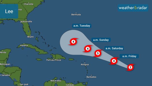
Why is it expected to turn?

There is the strong Bermuda high that is holding strong right now, guiding it to the west-northwest. But there will be a trough that will break the high and push it eastward. This will open a path for Lee to make a turn early to mid-next week as it is north of the southern Bahamas, staying away from Florida.

Average number of days to reach the USsaber más

Impacts before it impacts northern areas

As Lee travels parallel to the U.S. East Coast, Lee’s wind field will be extensive, bringing impacts to the marine and possibly the eastern coastline. Waves will be rough and seas very choppy. There could also be strong and dangerous rip currents in the next 7 to 9 days.

What’s next, after Lee? Tropical Depression 14

Invest 96L is officially classified as Tropical Depression 14 and will continue to get better organized and stronger over the next few days. It is traveling over the Cabo Verde Islands and conditions will gradually become more conducive for development as it moves west-northwest. There is plenty of time to monitor this system, but for now, it seems like it will only be an issue for mariners.

We will continue to bring you prompt updates on our app and on all of our social media platforms throughout the week and weekend. Check your hurricane plans. Enjoy the short week and the weekend.

**This same information can be seen in Spanish, written by our bilingual meteorologists if your phone is set to Spanish and using our app too. Tell your family and friends who only speak Spanish so that they can also be informed and stay safe, please.**

Irene Sans
Noticias destacadas
martes, 3 de junio de 2025

Última hora

El Etna ha vuelto a entrar en erupción
viernes, 6 de junio de 2025

Planifica tus noches

Agenda astronómica de junio
domingo, 1 de junio de 2025

Áreas enterradas

Un glaciar colapsa en Suiza
Más noticias
Te puede interesar
lunes, 26 de mayo de 2025

Temporada de huracanes 2025

Por encima del promedio
jueves, 29 de mayo de 2025

Lo bueno y malo

Lo que trae el viento: Polvo del Sahara
lunes, 12 de mayo de 2025

Diluvios, tormentas

Gran giro en el Radar, inundaciones repentinas
Todas las noticias
Weather & Radar

es.weatherandradar.com

instagramyouTubeContacto
Protección de datos | Aviso legal