Página de inicio
Tiempo Los Angeles
Radar del Tiempo
Radar de lluvia
Radar de temperatura
Radar de viento
Radar de rayos
Noticias
Recomendado
Descubre la aplicación
Widget del tiempo
Contacto
Apps
    Página de inicio / Artículos recomendados /

    Tropical update: Post-tropical storm Philippe heads to NE

03:40 p.m.
6 de octubre de 2023

Tropical update
Philippe heads to the Northeast, floods
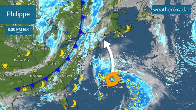
Post-Tropical Storm Philippe changed in characteristics as it travels west of Bermuda. Expect seas to be rough along the Northeast, nearshore, and offshore, and getting worse as it approaches New England.

Tracing the cold- Hello sweater weathersaber más

Philippe’s track has become more defined. It is likely that the storm will arrive in Maine very early on Sunday. It won’t likely be a Nova Scotia arrival, but there will be widespread strong gusts and heavy rains that could even reach Atlantic Canada. Keep in mind, that Philippe’s impacts will arrive up to a day before the center gets close. Additionally, a cold front will be bringing rain to the Northeast which will interact with Philippe’s arrival, making it a very soggy and gusty weekend across the entire northeastern United States.

A cold front will interact with Philippe, bringing a very soggy weekend for the Northeast.

USUAL WATCHES AND WARNINGS WON’T BE ISSUED BY THE NHC

The National Hurricane Center is coordinating with the Canadian Weather Office and the local National Weather Services across the Northeast. Official watches and warnings will be issued by the local offices, and not by the National Hurricane Center as they would for other systems. The reason? Has become a post-tropical storm, which means it lost its typical tropical characteristics. But this should not allow you to let your guard down.

Impacts

Bermuda could receive up to 3 inches of rain today, as well as strong gusts. As Philippe gets closer to the Northeast, there will be widespread rain from New York through New England. The rain will be courtesy of a cold front and Philippe, and up to 5 inches in some spots could be possible, but overall, between 1 to 3 inches are in the forecast. There could be some areas where flash floods could develop. Remember to turn around, don’t drown. Water could be higher than expected.

Gale warnings are in effect from the mid-Atlantic coast through the New England coast.

Seas will be very rough and dangerous. Large waves will impact much of the entire East Coast of the United States, with the highest waves across the Northeast courtesy also of Philippe and the exiting cold front which will continue to bring rough seas through early next week.

What else is out there in the Atlantic Basin?

Hurricane season is not over yet. Officially, there are still around 2 months left of the season. Activity during the stretch is usually more common near the U.S. coast and the western Caribbean, but there could still be a rogue African wave.

We will be monitoring a tropical wave that will exit Africa this weekend. It has a 50 percent chance of developing during the next 7 days. There is plenty of time to monitor this system and its track.

We will be watching over the tropics and Philippe’s impact this weekend across the Northeast. Please stay tuned to our updates on our app.

**This same information can be seen in Spanish, written by our bilingual meteorologists if your app is set to Spanish. Tell your family and friends who only speak Spanish so that they can also be informed and stay safe, please.**

Irene Sans
Noticias destacadas
El huracán Polo azota México. Alto riesgo de tormentas. . . lunes, 28 de septiembre de 2026
Huracán frente a las costas de México en WindRadar
lunes, 28 de septiembre de 2026

Alto riesgo de tormentas

El huracán Polo azota México
La niebla: un enemigo en otoño. ¡Precaución en carretera!. . . martes, 29 de septiembre de 2026
Imagen de un coche en un día de niebla densa.
martes, 29 de septiembre de 2026

¡Precaución en carretera!

La niebla: un enemigo en otoño
El verano más cálido de la historia. Cuatro meses de calor. . . domingo, 27 de septiembre de 2026
El verano de 2026 ha tenido un carácter extremadamente cálido en España. Y este año, el calor propio del verano se ha prolongado desde junio a septiembre.
domingo, 27 de septiembre de 2026

Cuatro meses de calor

El verano más cálido de la historia
Más noticias
Te puede interesar
Guía para activar alertas meteorológicas. Mantente seguro. . . sábado, 26 de septiembre de 2026
Alerts fll florida alertas
sábado, 26 de septiembre de 2026

Mantente seguro

Guía para activar alertas meteorológicas
El doble de la lluvia de septiembre en 72 horas. Nuevo México. . . miércoles, 23 de septiembre de 2026
miércoles, 23 de septiembre de 2026

Nuevo México

El doble de la lluvia de septiembre en 72 horas
Fuertes vientos azotan la costa este. Famoso "Nor'easter". . . viernes, 25 de septiembre de 2026
viernes, 25 de septiembre de 2026

Famoso "Nor'easter"

Fuertes vientos azotan la costa este
Todas las noticias
Weather & Radar

Tiempo y Radar también está disponible en

Google Play StoreApp Store

Compañía

Contacto Protección de datos Aviso legal Declaración de accesibilidad

Servicios

Subir imagen

Redes sociales

instagramyouTube