Página de inicio
Tiempo Los Angeles
Radar del Tiempo
Radar de lluvia
Radar de temperatura
Radar de viento
Radar de rayos
Noticias
Recomendado
Descubre la aplicación
Widget del tiempo
Contacto
Apps
    Página de inicio / Artículos recomendados /

    Tropical update: Storm threatens Texas, fired up Atlantic

03:26 p.m.
21 de agosto de 2023

Tropical update
Storm threatens Texas, fired up Atlantic

For the second consecutive day, another tropical storm is named in the Atlantic. This time we have Franklin in the Caribbean, Gert just east of the Lesser Antilles, and Emily, which will just keep on swimming, just keep swimming (sing it!). Closer, we now have Potential Tropical Cyclone 9, threatening southern Texas, and another tropical wave!

Atlantic is fired up!!

Let's start with Potential Tropical Cyclone 9, the robust tropical wave brewing in the Gulf of Mexico. it is moving west and there are tropical storm warning in effect for the South Texas coast. Remember Potential Tropical Cyclone means that the system has a high chance of becoming a tropical system, just doesn´t have the characteristic just yet, but it is so close to land that the National Hurricane Center labels it as such because residents need to be warned and authorities need to start being activated and preparing citizens. Special awareness for the Southern Texas and northern Mexico coast, as this system (likely Harold) is forecast to impact the region on Tuesday.

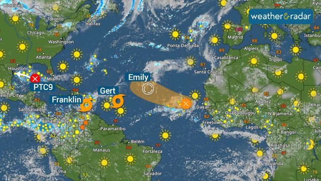
Franklin heading to the Hispaniola

Tropical Storm Franklin formed on Sunday afternoon. A tropical storm warning is now in effect for the southern coast of Haiti and the Dominican Republic, and a tropical watch is now in effect for the northern coast.

Franklin has 50 mph maximum sustained winds and is moving west at 12 mph. Franklin will be stomping on the brakes later on Monday as it prepares to make a turn to the north on Tuesday. This break will bring constant heavy rains to the central islands of the Caribbean. Between 2 to 4 inches of rain are possible, but some areas can get up to 6 in Puerto Rico. While in the DR and Haiti, up to 12 inches of rain can accumulate. Pay attention to our updates.

Franklin could be a strong tropical storm, near hurricane status before making landfall on Tuesday night near Barahona in the Dominican Republic. It will travel through the highest mountains in the Caribbean and exit quickly over the Atlantic waters. This system could intensify once again later this week, but it is expected to remain over the open central Atlantic.

Tropical Storm Gert

Monday’s newest storm is Gert. This was tropical depression 6 over the weekend and it briefly intensified this morning, therefore the NHC decided to baptize it. Luckily, it will not last too long. It is still expected to enter a hostile environment just before approaching the northeastern Caribbean, which will end its tropical depression life late Monday night.

Post-Tropical Storm Emily

Emily has lost strength, now a post-tropical cyclone, and will continue to do so as it moves over the central Atlantic waters. It is moving very slowly. No threat to land.

Tropical wave in far Eastern Atlantic

Finally, the last tropical wave. It is located near the Cabo Verde Islands. It is expected to become better organized and acquire a name (maybe Idalia, if nothing else pops up before). Luckily this system is forecast to follow Emily’s footsteps and remain over the open Atlantic waters.

Our team of meteorologists is closely watching PTC 9 and the rest of the tropics. We will be bringing you updates about the threats this system will bring to help you make the safest decisions. **This same information can be seen in Spanish, written by our bilingual meteorologists if your phone is set to Spanish and using our app too. Tell your family and friends that only speak Spanish so that they can also be informed and stay safe, please.**

Irene Sans
Noticias destacadas
Domo de calor en Europa. Fenómeno meteorológico. . . lunes, 22 de junio de 2026
lunes, 22 de junio de 2026

Fenómeno meteorológico

Domo de calor en Europa
Riesgo de tormentas en Irlanda y Escocia. Situación excepcional. . . miércoles, 24 de junio de 2026
Mapa meteorológico de Irlanda y el Reino Unido con las zonas de alerta señaladas y un símbolo de alerta de rayos. Aviso de mayor riesgo de fenómenos meteorológicos extremos el jueves.
miércoles, 24 de junio de 2026

Situación excepcional

Riesgo de tormentas en Irlanda y Escocia
La ola de calor deja 211 fallecidos. Impacto mortal del calor. . . viernes, 26 de junio de 2026
España atravesó, desde el domingo 21 de junio hasta el miércoles 24 de junio, la primera ola de calor del verano. Este episodio de altas temperaturas consolidó el 22 y 23 de junio como los días más cálidos registrados en la España peninsular durante este mes desde 1950.
viernes, 26 de junio de 2026

Impacto mortal del calor

La ola de calor deja 211 fallecidos
Más noticias
Te puede interesar
Fuertes tormentas azotan las Llanuras. Front Range, Kansas. . . sábado, 20 de junio de 2026
sábado, 20 de junio de 2026

Front Range, Kansas

Fuertes tormentas azotan las Llanuras
Calor abrasador en Texas. Sensación térmica +100F. . . jueves, 18 de junio de 2026
Nos espera un día caluroso en Texas.
jueves, 18 de junio de 2026

Sensación térmica +100F

Calor abrasador en Texas
Nuestra herramienta más popular. El Radar del Tiempo. . . martes, 23 de junio de 2026
martes, 23 de junio de 2026

El Radar del Tiempo

Nuestra herramienta más popular
Todas las noticias
Weather & Radar

Tiempo y Radar también está disponible en

Google Play StoreApp Store

Compañía

Contacto Protección de datos Aviso legal Declaración de accesibilidad

Servicios

Subir imagen

Redes sociales

instagramyouTube