Página de inicio / Artículos recomendados /

Tropical update: Tropical Depression# 6 & 4 tropical waves

11:12 PM
19 de agosto de 2023

Tropical update
Depression #6 & 4 tropical waves

The Atlantic is very active this weekend. The Atlantic is very active this weekend.

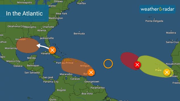
This Saturday we add another tropical wave to our long list of areas that we are monitoring over the Atlantic basin. Also, almost at the end of the afternoon, the National Hurricane Center officially upgraded one of the waves as a tropical depression.

Tropical Depression #6

There are two good news about this system: It won't live very long as it fights against dry air and strong wind shear. It will move west, but before reaching the northeastern Caribbean it will lose strength, returning to its tropical wave state.

A tropical wave parade

The rest of the Atlantic is still active. There are tropical waves ahead and behind Tropical Depression number 6. A tropical wave is about to enter the Caribbean and has a 40 percent potential to become a tropical system within the next 2 days and 60 percent within 7 days. This system may continue to get better organized and be upgraded early next week. The Lesser Antilles will continue to have rains due to this disturbance during the weekend.

Hilary to Cali: Threats and timingsaber más

A newly emerged tropical wave from Africa has little chance of developing over the next 7 days. We have plenty of time to watch it and determined where it will go.

The tropical wave over the central Atlantic, Invest 99L, is most likely the next system that will be named. It has a 70 percent chance for development over the next 2 days. The good news is that it will stay over the open waters of the Atlantic.

Florida with lots of rain

Finally, Florida had a cloudy and rainy day this Saturday. Showers and storms will continue to increase in coverage and intensity on Sunday. The tropical wave will be crossing southern Florida and once it enters the Gulf of Mexico it could develop, becoming better organized, strengthening, and get named. For now, this Saturday night has a 50 percent chance of development over the next 7 days, so its development will be slow.

This weekend we will be watching how the Atlantic evolves, but also what happens with Hilary, since southern California is hammered with heavy rains.

**This same information can be seen in Spanish, written by our bilingual meteorologists if your phone is set to Spanish and using our app too. Tell your family and friends that only speak Spanish so that they can also be informed and stay safe, please.**

Irene Sans
Noticias destacadas
domingo, 13 de julio de 2025

Regusto invernal

Los Alpes reciben nevadas veraniegas
martes, 15 de julio de 2025

Suceso inusual en EE. UU.

Tornado de fuego en Utah
Incendio forestal cerca de Marsella: columna de humo visible en el radar meteorológico
sábado, 12 de julio de 2025

Cerca de Marsella

Incendios forestales en el sur de Francia
Más noticias
Te puede interesar
miércoles, 2 de julio de 2025

Zonas propensas

Qué esperar de los trópicos en julio
Heavy rain led to flooding in Kansas City overnight.
jueves, 17 de julio de 2025

Más en riesgo

Inundaciones repentinas en Kansas City
viernes, 4 de julio de 2025

Lluvias, inundaciones

Se forma la Depresión Tropical 3 cerca del Sureste
Todas las noticias
Weather & Radar

es.weatherandradar.com

instagramyouTubeContacto
Protección de datos | Aviso legal | Declaración de accesibilidad