Página de inicio
Tiempo Los Angeles
Radar del Tiempo
Radar de lluvia
Radar de temperatura
Radar de viento
Radar de rayos
Noticias
Recomendado
Descubre la aplicación
Widget del tiempo
Contacto
Apps
    Página de inicio / Noticias /

    April heatwave - A.C. workout for the East

01:42 p.m.
15 de abril de 2026

April heatwave
A.C. workout for the East

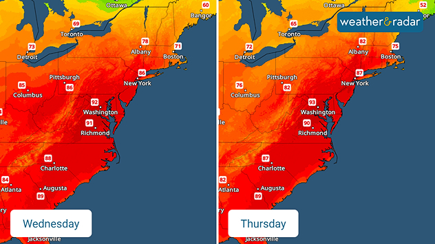
Wednesday's & Thursday's high temperature forecast.
TemperatureRadar: Wednesday's & Thursday's high temperature forecast.

April is known for bringing spring showers and cool temperatures, comfortable enough for open windows. But a summer-like heatwave is giving those air conditioners an early run.

High-temperature records as old as 130 years are on the chopping block on Wednesday as highs head into the 80s and 90s from the Midwest to the East Coast.

Washington, D.C., and New York City will be hotter than Miami on Wednesday and Thursday, about 20 to 30 degrees warmer than average for this time of year.

The TemperatureRadar shows the hottest of the heat bubble shifting east through the latter half of the week, but it will take a strong weekend cold front to bring the thermometer back down to average temperatures.

Becca Parker
Noticias destacadas
Huracán Simón: México sigue preocupado. Fuerte huracán. . . lunes, 12 de octubre de 2026
El WindRadar muestra el huracán Simón frente a la costa del Pacífico de México, cerca de Puerto Vallarta. Los colores violeta y rojo indican los vientos más fuertes. A la izquierda se ve una cámara web de Jalisco.
lunes, 12 de octubre de 2026

Fuerte huracán

Huracán Simón: México sigue preocupado
Tiempo tormentoso en el Mediterráneo. Aumenta el riesgo extremo. . . miércoles, 30 de septiembre de 2026
Imagen dividida. A la izquierda, un mapa meteorológico de España y Francia con precipitaciones, temperaturas y símbolos meteorológicos. A la derecha, una calle inundada con un coche.
miércoles, 30 de septiembre de 2026

Aumenta el riesgo extremo

Tiempo tormentoso en el Mediterráneo
Duelo meteorológico sobre Europa. Lluvias y tormentas. . . sábado, 3 de octubre de 2026
En estos momentos se está formando una fuerte borrasca en el Atlántico. Traerá tiempo adverso a varias zonas de Europa.
sábado, 3 de octubre de 2026

Lluvias y tormentas

Duelo meteorológico sobre Europa
Más noticias
Te puede interesar
Repercusiones del huracán Isaias tras tocar tierra. Lluvias en el sureste. . . sábado, 10 de octubre de 2026
Repercusiones de Isaias en el sureste
sábado, 10 de octubre de 2026

Lluvias en el sureste

Repercusiones del huracán Isaias tras tocar tierra
Marejada ciclónica e inundaciones. Isaías llega a la costa. . . viernes, 9 de octubre de 2026
viernes, 9 de octubre de 2026

Isaías llega a la costa

Marejada ciclónica e inundaciones
Un final de fin de semana lluvioso para algunos. Restos de Isaías. . . domingo, 11 de octubre de 2026
While Isaias may have made landfall near Destin, Fla., Friday night, the hurricane's remnants will bring a soggy end to the weekend hundreds of miles away from the point of landfall.
domingo, 11 de octubre de 2026

Restos de Isaías

Un final de fin de semana lluvioso para algunos
Todas las noticias
Weather & Radar

Tiempo y Radar también está disponible en

Google Play StoreApp Store

Compañía

Contacto Protección de datos Aviso legal Declaración de accesibilidad

Servicios

Subir imagen

Redes sociales

instagramyouTube