Página de inicio
Tiempo Los Angeles
Radar del Tiempo
Radar de lluvia
Radar de temperatura
Radar de viento
Radar de rayos
Noticias
Recomendado
Descubre la aplicación
Widget del tiempo
Contacto
Apps
    Página de inicio / Artículos recomendados /

    Hilary targets California: Impacts, threats & timing to California & surroundings

01:30 a.m.
20 de agosto de 2023

Hilary targets California
Impacts, threats & timing

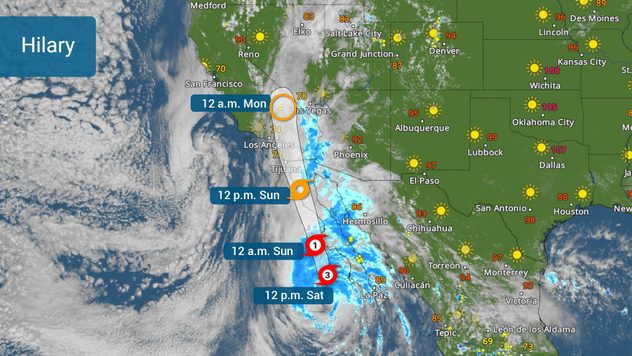
Hilary has started to make the turn northward and on Saturday afternoon it is still a major category 3 hurricane. Southern California, southwestern Arizona, and the south and western regions of Nevada prepare for torrential rains that could bring dangerous floods and landslides.

Hilary's track issued on Saturday at 3pm MT

The good news is that Hilary will continue to move northward and is about to enter a much cooler swath of Pacific waters, this will cut down the intensity rapidly during the next 12 to 24 hours. But please be aware that Hilary is a massive storm and although intensity will be diminishing, hurricane categories only refer to wind speeds. Hilary will gain forward speed as it loses strength, still dropping lots of rain for SoCal and parts of Nevada.

The biggest threat for Southern California is the torrential rains that much of the terrain cannot drain safely or fast enough. After all, the highest rainfall is forecast to affect the interior areas of southern California, much of it a desert. Mountains are in for large amounts of rain, that could cause landslides. Residents near the Peninsular Ranges and the eastern portion of the Transverse Mountains should be especially aware.

Hazards will be highly dependent on the location and the track Hilary's center takes.

The central Imperial northward through the Inland Empire is in for very large quantities of rainfall that could reach 10 inches in some isolated spots. The highest rainfall will be falling through Sunday night. Widespread amounts across the Empires will range between 3 and 6 inches.

Tropical terminology to knowsaber más

San Diego and Orange Counties are not expected to receive such high amounts but, rest assured that there would be some dangerous floods. Rainfall will range between 2-4 inches along the coast extending through Los Angeles.

Atlantic: Depression #6 & 4 wavessaber más

What worries meteorologists the most?

Rainfall, tornadoes, winds, and surf.

Excessive rainfall will not only cause dangerous floods, especially across those areas where the drainage is not the best, due to natural conditions (like the desert) but also across those areas with heavy populations and lots of concrete. Please remember, turn around, and don’t drown. Riverbeds are especially dangerous, so if you live in southern California or areas anywhere in the Southwestern U.S. pay close attention. If you are in an area forecast for excessive rainfall of downslope a river near mountains, you should consider going to higher grounds and staying there through Monday.

How does a hurricane form and its riskssaber más

Winds will be the strongest over elevated terrain. The mountains will experience the strongest gusts and be confined over inland areas of the forecast track.

Tornadoes are also a possibility, especially among those rainbands moving inland over parts of the lower Colorado River Valley, and Imperial Valley regions. Think to the right of where the center of the storm moves. Some tornadic storms will travel in the storms embedded in rainbands.

Sunday through much of Monday won’t be the best days to be in the water. Even after the rain tapers off in Southern California, there will be large swells that will bring life-threatening surf and rip currents.

Make sure to have your alerts turned on. Have at least 3 ways of receiving weather alerts, even as Hilary downgrades. Our team of meteorologists will be working throughout the weekend to keep you posted about the latest changes on track and impacts. Our weather reporter has been deployed to cover what's happening across Southern California.

**This same information can be seen in Spanish, written by our bilingual meteorologists if your phone is set to Spanish and using our app too. Tell your family and friends that only speak Spanish so that they can also be informed and stay safe, please.**

Irene Sans
Noticias destacadas
Conducir bajo neblina densa. Medidas de seguridad. . . domingo, 13 de septiembre de 2026
Neblina niebla
domingo, 13 de septiembre de 2026

Medidas de seguridad

Conducir bajo neblina densa
Riesgo tormentoso en el Mediterráneo. Alertas activas. . . jueves, 10 de septiembre de 2026
A la izquierda, nubes oscuras de tormenta sobre la costa. A la derecha, un mapa meteorológico muestra tormentas sobre el Mediterráneo occidental con símbolos de alerta por tornados, tormentas y granizo.
jueves, 10 de septiembre de 2026

Alertas activas

Riesgo tormentoso en el Mediterráneo
Las tormentas mantienen a Europa en vilo. Lluvias fuertes, granizo. . . domingo, 20 de septiembre de 2026
El radar meteorológico muestra fuertes tormentas y numerosos relámpagos sobre el norte de Italia.
domingo, 20 de septiembre de 2026

Lluvias fuertes, granizo

Las tormentas mantienen a Europa en vilo
Más noticias
Te puede interesar
Más señales de otoño. Llegan días más frescos. . . viernes, 18 de septiembre de 2026
viernes, 18 de septiembre de 2026

Llegan días más frescos

Más señales de otoño
Cuándo comienza y por qué cambia la fecha cada año. Equinoccio de otoño. . . martes, 22 de septiembre de 2026
martes, 22 de septiembre de 2026

Equinoccio de otoño

Cuándo comienza y por qué cambia la fecha cada año
La histórica temporada de huracanes de 2026. Sin huracanes, por ahora. . . miércoles, 23 de septiembre de 2026
miércoles, 23 de septiembre de 2026

Sin huracanes, por ahora

La histórica temporada de huracanes de 2026
Todas las noticias
Weather & Radar

Tiempo y Radar también está disponible en

Google Play StoreApp Store

Compañía

Contacto Protección de datos Aviso legal Declaración de accesibilidad

Servicios

Subir imagen

Redes sociales

instagramyouTube