Página de inicio
Tiempo Los Angeles
Radar del Tiempo
Radar de lluvia
Radar de temperatura
Radar de viento
Radar de rayos
Noticias
Recomendado
Descubre la aplicación
Widget del tiempo
Contacto
Apps
    Página de inicio / Artículos recomendados /

    Tropical storm-like: Tornadoes, gusts & flood possible

07:08 p.m.
15 de diciembre de 2023

Tropical storm-like
Tornadoes, gusts & flood possible

Recommended external content from YouTube

We need your consent to show content from YouTube. You can withdraw your consent at any time.

I agree that content from YouTube will be displayed to me.
Privacy policy

SUMMARY FOR FLORIDA:

The storm will dissect the Florida peninsula, bringing severe conditions, then emerge over the eastern Atlantic. Once east of Florida, colder, drier air will slowly filter over Georgia and Florida, and the weather will gradually improve early next week.

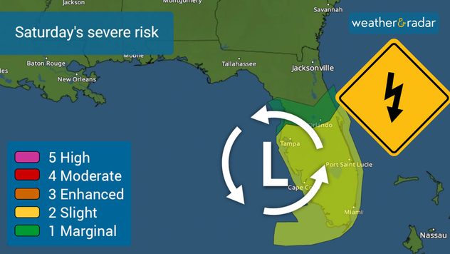
We are forecasting an active weekend, starting in Florida, where the risk of severe storms including the possibility of tornadoes will be present on Saturday. Have multiple ways to receive weather alerts.

The greatest risk will be the possible development of tornadoes over central Florida on Saturday night and early Sunday morning.

As South Florida continues to deal with lots of clouds and showers, the situation is about to get worse and expand all over the state. A low-pressure system, inches closer to the state at the end of the week and is likely to bring tropical storm-like conditions throughout the weekend.

This storm is likely to gain strength as it moves over the eastern Gulf of Mexico, so the Florida Peninsula should prepare for a very rainy Saturday, with gusts that could exceed 60 mph. The biggest concern is the possibility of tornadoes forming and it is more serious because these tornadoes would form at nighttime. It is important that you have several ways to receive tornado warnings. Remember that a tornado warning means that a tornado has been detected, by radar or visually, and you should go to a safe location at your home or work.

What will happen after it crosses Florida?

The Carolinas through the Mid-Atlantic will be dealing with dangerous weather early next week. The main hazards will be wind, heavy rains, and dangerous seas and surf. It is possible for the center of this storm to border the Georgia/South Carolina coast and move inland, but while it is bordering these states very dangerous storm surge could affect the entire coast of South and North Carolina on Sunday.

By Monday, the center of the storm will be approaching the Northeast, but the winds will then swing around and be mainly from the north-northwest on Monday for Georgia, Florida and the Carolinas.

How much rain?

South Florida will be the bullseyes, with around 8 inches still possible throughout this entire event. Let’s remember that rain has been battering the area since Wednesday and will continue until late Saturday. The rest of the Peninsula could receive around 4 inches with some isolated spots with higher amounts.

Once the storm crosses Florida and advances over the Carolinas and the Mid-Atlantic states, precipitation could also be high, causing flash flooding. For now, the forecast indicates that accumulations in the Carolinas may also approach 8 inches in isolation. The Florida Panhandle, Georgia, and South Carolina could see more than 5 inches of rain through Monday night. Virginia, northern North Carolina, and Maryland could receive between 3 and 5 inches, as the system is expected to be moving quicker at this point.

With heavy rain, especially in areas soaked by recent rains, flash flooding could develop. Please avoid crossing flooded areas. Turn around, don't drown.

Secure outdoor loose objects and decorations!

The winds will be strong as the system comes closer to Florida on Friday and Saturday. In fact, winds have been blowing strongly on Thursday, with gusts that have reached 30 mph at Miami International Airport. Wind advisories are in effect until Sunday, as gusts could reach 45 mph. For Central and Northern Florida, gusts are also expected to be strong, reaching 50 mph at times.

Wind advisories will likely be issued for many more areas in Florida, Georgia, and the Carolinas by the end of the week and into the weekend. This storm could bring very strong gusts above 55 mph and sustained winds between 30 and 40 mph.

SAFETY TIP:

We understand that it takes lots of effort, but if you are in an area under wind advisories, you should consider bringing any Christmas decorations placed outdoors, as in the wind they can become projectiles, causing damage.

We will continue to monitor this system throughout the weekend and will be fully staffed to track the impacts of this event.

**This information, written by our meteorologists, is also available in Spanish using our app in this language or in tiempoyradar.com

Irene Sans
Noticias destacadas
Incendios forestales en España y Francia. Catástrofe en Europa. . . lunes, 27 de julio de 2026
La situación de los incendios forestales en el suroeste de Francia y en España sigue agravándose.
lunes, 27 de julio de 2026

Catástrofe en Europa

Incendios forestales en España y Francia
Fuertes tormentas azotan Italia. Granizo y destrozos. . . domingo, 19 de julio de 2026
Fuertes tormentas azotaron el norte de Italia este pasado miércoles. Las llamadas supercélulas recorrieron una amplia franja del país, desde el Piamonte hasta Friuli-Venecia Julia, pasando por Emilia-Romaña.
domingo, 19 de julio de 2026

Granizo y destrozos

Fuertes tormentas azotan Italia
Alerta de tifón en China. Hasta 20''de lluvia. . . viernes, 24 de julio de 2026
Mapa meteorológico de la costa sur de China y Taiwán con un fuerte ciclón tropical. El ojo de la tormenta se encuentra cerca de la ciudad costera de Shantou, en la provincia china de Guangdong. Alrededor del núcleo, los intensos tonos rojos, rosas y violetas indican ráfagas de huracán, mientras que un gran campo de viento de color naranja se extiende hasta la costa occidental de Taiwán. Una señal de advertencia de manga de viento superpuesta indica la presencia de peligrosos vientos de tormenta. Se muestran ciudades como Hong Kong, Guangzhou, Xiamen, Taipéi y Taichung, así como las velocidades del viento y las líneas de flujo blancas que ilustran la circulación ciclónica del aire.
viernes, 24 de julio de 2026

Hasta 20''de lluvia

Alerta de tifón en China
Más noticias
Te puede interesar
Persiste la calidad del aire peligrosa. Humo desde Canadá. . . viernes, 17 de julio de 2026
viernes, 17 de julio de 2026

Humo desde Canadá

Persiste la calidad del aire peligrosa
Marejada ciclónica de hasta cuatro pies. Costa del Golfo peligrosa. . . martes, 21 de julio de 2026
martes, 21 de julio de 2026

Costa del Golfo peligrosa

Marejada ciclónica de hasta cuatro pies
Bertha, con su forma asimétrica, avanza hacia el oeste. ¿A quién afectará?. . . jueves, 23 de julio de 2026
jueves, 23 de julio de 2026

¿A quién afectará?

Bertha, con su forma asimétrica, avanza hacia el oeste
Todas las noticias
Weather & Radar

Tiempo y Radar también está disponible en

Google Play StoreApp Store

Compañía

Contacto Protección de datos Aviso legal Declaración de accesibilidad

Servicios

Subir imagen

Redes sociales

instagramyouTube